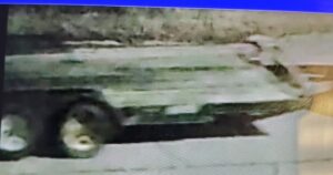
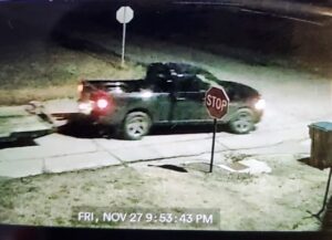
PRECAUTIONARY
A Flood Watch means there is a potential for flooding based on current forecasts. You should monitor later forecasts and be alert for possible Flood Warnings. If you live in an area prone to flooding, be prepared to take action should flooding develop. Do not enter or cross flowing water or water of unknown depth, and remember, flood waters are harder to see at night. Never cross a barricaded road.
LOCATION
Portions of southern Illinois...southwest Indiana and southeast Missouri, including the following areas, in southern Illinois, Alexander, Franklin, Hamilton, Jackson, Johnson, Pulaski, Saline, Union, White and Williamson. In southwest Indiana, Gibson and Pike. In southeast Missouri, Bollinger, Butler, Cape Girardeau, Carter, Perry MO, Ripley, Scott, Stoddard and Wayne MO.
INFO1
From 6 PM CST this evening through Sunday morning
INFO2
A consistent signal for locally heavy rain is forecast, especially tonight. Storm total average rainfall is forecast to range from one and a quarter to two and a quarter inches in the Watch area and, with thunderstorms forecast, localized higher totals up to 3 inches or more are possible. This amount of cumulative rainfall will be falling on recently soaked grounds from melted snowfall, so the ability to soak in all this expected rainfall will be compromised and likely to cause flood issues.
Steve Pascal
January 7, 2021 at 10:57 am4 door? Look again or maybe the police should look again. Seriously?
Ray
January 7, 2021 at 3:08 pmLooks like a 4 door to me
Rosemary York
January 7, 2021 at 7:05 pmThat’s a 4 door for sure
Wolf1018
January 8, 2021 at 2:42 amMaybe if you count the tailgate and hood as doors!!! If you enlarge the picture and look at it as a 4door, the front door would be 1/3 the size of the back door. At any rate- Is this the best picture the police can come up with? One where the stop sign impedes the image of the vehicle?